
All large works project inevitably have an impact on the environment: vegetation, fauna, water and relief are affected by the work during the execution of the project and also later, after the infrastructure is put into operation. Ensuring the prevention, elimination, or mitigation of this impact is the objective of environmental project management, which emerged in Spanish legislation in the 1990s, along with legislation requiring environmental assessment of plans and projects.
“Participating in the entire process, from evaluation to operation, has given us a comprehensive, integrated view of the implementation and deployment of linear infrastructure. The experience gained with the Spanish high-speed railway lines has been applied to other international railway and highway projects”.
Sergio Mora, biologist and environmental engineer (Ineco)
Ineco began developing its project environmental management departments in 1999, on the Madrid-Zaragoza-French Border high-speed railway line for the Gestor de Infraestructuras Ferroviarias (GIF), which later became Adif. Since then, it has continued to work on different high-speed lines throughout Spain, with a multi-disciplinary team made up of professionals from various fields: forest engineering, forestry, environmental sciences, biology, chemistry, geology, archaeology and cultural heritage.
“It is very satisfying for all the staff who form (or have formed) part of the team, to visit the places where they have worked years later and be unable to distinguish where the landfill was or where work was done on a river that appeared impossible to restore”.
Ignacio Pandelet, technical forest engineer (Ineco)
The next section describes some of the team’s more important projects.
A DINOSAUR UNDER THE TRACKS
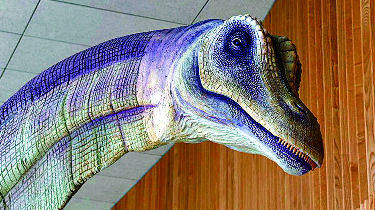
‘LO HUECO’ PALAEONTOLOGICAL SITE
Coordination: Pepa Ferrer, environmental engineer and Emilia de Aragón, archaeologist
Location: Madrid-Levante high-speed line (Fuentes, Cuenca)
Subject area: arqueología/paleontología
Date: 2007-2008
CHALLENGE: in 2007, earthmoving for the construction of a cut-and-cover tunnel in Fuentes (Cuenca) for the high-speed line to Levante uncovered more than 8,000 fossils from the Late Campanian-Early Maastrichtian (Late Cretaceous) (see IT47) including 23 large sauropod specimens. 80 million-year-old flora and fauna were found in the palaeochannel.
“It was undoubtedly the most interesting palaeontological site we encountered during the construction of the high-speed lines in Spain. So much so that some of the 23 dinosaurs found have been presented in different international forums”.
Pepa Ferrer and Emilia de Aragón, coordinators
SOLUTION: due to the infrastructure’s requirements, more than 60 archaeologists and palaeontologists and 40 assistants had to carry out the excavation in shifts, working day and night. An emergency excavation was done to meet the project’s tight deadlines and also protect the site, which covered more than 10,000 m2.
INTENSIVE CARE
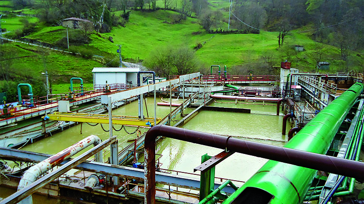
WATER MANAGEMENT AND HANDLING IN THE PAJARES TUNNELS
Coordination: David Luengo, environmental engineer biologist
Location: Pajares bypass
Subject area: wastewater management
Date: 2004-present
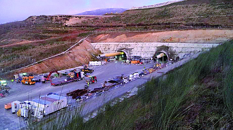
CHALLENGE: the excavation of the Pajares tunnels represents one of the biggest civil engineering challenges in Spain. It is also challenging in terms of the environment, since the project is located inside the Las Ubiñas-La Mesa Natural Park, a Biosphere Reserve, a brown bear habitation area, and the Peña Ubiña SCI in the Natura 2000 network.
As a result of the difficult geography and geotechnical conditions of the Cantabrian mountain range, during the tunnel excavation (twin-tube tunnel 25 km long), the volume of water generated during the excavation with the tunnel boring machines exceeded the predicted amounts. In addition, due to the environmental importance of the Huerna River where the water is discharged, the Hydrographic Confederation of Cantabria requires very strict discharge parameters. Another difficulty is the limited space and lack of definition of the construction plans to determine the placement of treatment facilities.
SOLUTION: new hydrogeological studies were carried out during the execution of the work. These indicated that the water supply inside the tunnels would be higher than initially estimated, and that extraordinary measures should be taken to protect the hydrological system, and treat the water from the tunnel excavations. The project’s environmental management department is coordinating the improvement of the original measures included in the construction project, and several industrial wastewater treatment plants (IWWTP) will be constructed, with successive expansions to treat 100% of the flow from the tunnels and ensure that the treated water discharged to the river complies with the parameters required by the Confederation in the discharge authorizations. A monitoring and analytical control program is also being implemented and coordinated to verify that effluents comply with the specified values.
RISING TO THE OCCASION
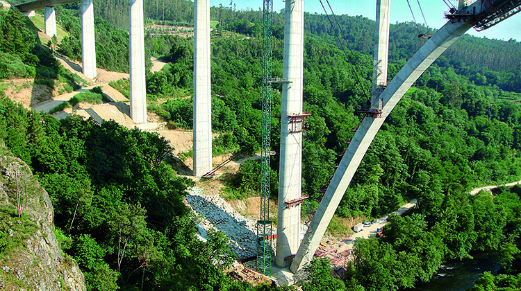
ENVIRONMENTAL INTEGRATION OF THE VIADUCT OVER THE ULLA RIVER (OURENSE-SANTIAGO LINE)
Coordination: Luis Álvarez-Pardiñas, biologist
Location: Galicia high-speed line. Ourense-Santiago Axis. Silleda (Dornelas)-Vedra-Boqueixón section
Subject area: environmental integration and restoration
Date: 2008-2011
CHALLENGE: of the 38 viaducts that were built on the high-performance axis between Ourense and Santiago, in service since 2011, the Ulla river viaduct stands above the rest. The construction of the viaduct, 117 metres high, 168 metres long and with pillars more than 90 metres high, was a major challenge, both technically and environmentally due to the high risk of erosion and the extreme difficulty of environmental integration and restoration of the area. The bridge is located in an area of high ecological value, protected as a Special Protection Zone of the Natural Values of the “Ullla-Deza River System”, whose well-conserved banks provide a magnificent example of Atlantic riverbank habitats, with alders, willows and ash trees, and a wide abundance of fish species, such as Atlantic salmon, sea lamprey, and trout living in its waters.
“The result was a model integration that received the ‘Aqueduct of Segovia’ award for the high level of environmental protection achieved during its construction, among other achievements”.
Luis Álvarez-Pardiñas, coordinator
SOLUTION: the Ineco team coordinated all the preventive, protective and corrective measures established in the Environmental Impact Statement (EIS) in regard to earthworks, occupation of space, construction waste, noise and impact on vegetation, and general actions to protect the historical and cultural heritage, before, during and after the viaduct work, in addition to the final replanting and landscape restoration work.
BETWEEN THE RIVER AND THE MOUNTAINS
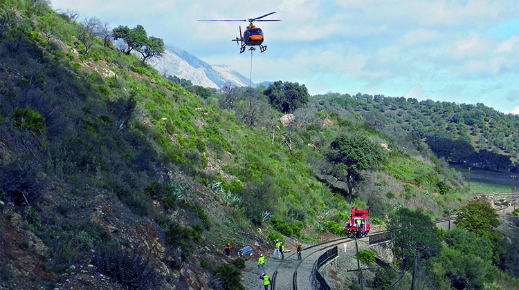
RENOVATION OF THE RONDA-ALGECIRAS TRACK
Coordination: Iñaki G. Seoane, mountain engineer
Location: Ronda-Algeciras railway line
Subject area: impact on protected natural areas
Date: 2009-2010
CHALLENGE: the railway line between Ronda and Algeciras is a conventional line that is strategically important for freight transport in Spain as it provides the only rail outlet from the country’s largest port in Algeciras. It is also unique from the environmental point of view, as it crosses steep and mountainous terrain, enclosed in the canyon of the Guadiaro River, passing through the Natural Parks of Sierra de Grazalema and Los Alcornocales. The renovation work therefore had to be carried out as quickly as possible, but at the same time, had to be compatible with the environmental protection of these valuable natural spaces. Numerous protected species, such as the imperial eagle (Aquila adalberti), vulture (Neophron percnopterus), griffon vulture (Gyps fulvus) and mountain goat (Capra pyrenaica) are native to the area.
“The biggest challenge was working with the platform access limitations associated with the geography in the vicinity of the Guadiaro River and the restrictions of the Natural Parks through which the track passes. Coordination between the people in charge of these spaces and the project managers was essential to avoid irreparable impacts on the environment”.
Iñaki García Seoane, coordinator
SOLUTION: the management of both natural parks was involved in the handling and resolution of incidents and incompatibilities between the use of the land and the works. Biological stoppages, the location of auxiliary facilities and accesses were defined based on the actual data on the species present and the needs of the agencies responsible for the parks. Railway service was shut down during most of the work, which affected freight transport, but allowed compliance with the EIS.
ON DANGEROUS GROUND
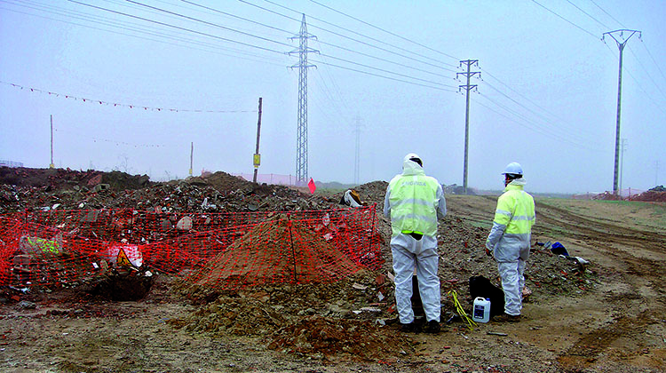
MANAGEMENT OF CONTAMINATED SOIL FROM THE PLOTS OF THE NEW HIGH-SPEED STATION IN MEDINA DEL CAMPO
Coordination: Sergio Mora Alonso, biologist and environmental engineer
Location: Medina del Campo, Madrid-Galicia high-speed line
Subject area: waste management
Date: 2015-2016
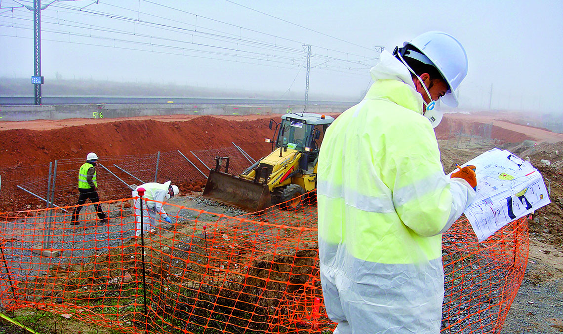
CHALLENGE: during the initial phase of the works, the area chosen for the station was found to be contaminated by illegally-dumped debris. According to the official documentation pertaining to this land, the expropriated plots were involved in sanctions proceedings as a result of the dumping of hazardous wastes containing mercury (Hg) prior to the work. In addition, to make matters worse, large areas with fibre-cement sheets containing asbestos were also discovered. Asbestos is a fibrous mineral that was widely used for many years in construction for its high flame-retardant and insulating properties. It was later found to be highly carcinogenic through the inhalation of the fibres.
“Once the surplus earth containing mercury or asbestos had been identified and classified, it was taken to safe dump sites, controlled or inert landfills, by an authorized waste management company”.
Sergio Mora, coordinator
SOLUTION: the biggest challenge was to adequately classify and manage the surplus earth coming from the works, to ensure proper traceability and separation of the soil based on hazard levels, and also, to make this work compatible with the current work plan. The problem was approached with caution, carrying out representative analyses of the affected area to detect the possible presence of both mercury and asbestos.
DETONATING FACTOR
Contamination caused by the use of ANFO for blasting
Coordination: Esther Izquierdo, biologist / Enrique Martínez Agüera, forest engineer
Location: La Canda tunnels, (Ourense)
Subject area: water quality management
Date: 2014
CHALLENGE: during the excavation of the railway tunnel (see IT53), blasting of rocky terrain was required to loosen the rock and facilitate drilling. One of the explosives used in this process was ANFO, an explosive that combines ammonium nitrate and petroleum-derived fuel oil. It was discovered that the traces of this toxic compound would eventually end up in the waters of nearby rivers, posing a risk for both aquatic wildlife and humans.
SOLUTION: the first step was to inform and educate all workers in order to avoid unnecessary dumping on the land that would eventually reach the waterways. They also began to use cartridge (instead of granular) explosives to facilitate handling. Water monitoring and treatment measures were strengthened, and aerators were installed in the settling ponds, in order to promote denitrification and removal of ammonium ions from the water.
SAFE GARDENS
RESTORATION OF AGRICULTURAL LAND IN THE AGRICULTURAL PARK OF CATALONIA
Coordination: Martí Segret, environmental engineer
Location: Madrid-Zaragoza-Barcelona-French Border high-speed line (Sant Boi and El Prat de Llobregat, Barcelona)
Subject area: landscape integration and restoration of agricultural land
Date: 2006-2008
CHALLENGE: the Baix Llobregat is one of Catalonia’s oldest and most fertile agricultural areas, with a climate that is well-suited for vegetable cultivation, outdoor fruit trees and protected crops, particularly in the delta and lower river basin of the Llobregat River. The construction of a 1,740 metre underground section as part of a cut-and-cover tunnel affected this agricultural area with its significant cultural, economic and ecological value: the Agricultural Park of Baix Llobregat.
“The agricultural land was restored by spreading and levelling layers of sand, silt and topsoil taken previously from the farmlands themselves”.
Martí Segret, coordinator
SOLUTION: the work consisted of levelling the ground with sand and conditioning to the surface level of the ground with two layers of assimilable silts and topsoil, previously taken from the property affected by the track.
GETTING BACK ON TRACK
ECOLOGICAL AND LANDSCAPE INTEGRATION ALONG THE LLOBREGAT RIVER AND THE SURROUNDING AREA
Coordination: Rubén Segura, biologist
Location: Madrid-Barcelona-French Border high-speed line
Subject area: landscape integration–corrective /compensatory measures
Date: 2003-2010
CHALLENGE: the construction of the platforms for the Papiol-Sant Vicenç dels Horts and Sant Vicenç dels Horts-Santa Coloma de Cervella sections of the high-speed line affected the area surrounding the Llobregat River. Both the Environmental Impact Statement (EIS) and local regulations required that the necessary measures be taken.
“Some of the more important actions carried out included the naturalization of the rockfill riverbank protection, the expansion of the Aiguamolls of Molins de Rei, the construction of fish ladders and other actions, such as the construction of access roads and a riverbank road”.
Rubén Segura, coordinator
SOLUTION: one of the more important actions carried out was the naturalization of the rockfill protection along the banks of the river by adding topsoil followed by revegetation with hydroseeding and planting, the expansion of the Aiguamolls (wetlands) of Molins de Rei and the construction of fish ladders. In addition, works were undertaken to maintain and enhance the river’s morpho-hydrodynamic conditions, as well as others aimed at ensuring longitudinal connectivity, such as the construction of access roads and a road along the riverbank.
ROCK-SOLID STABILITY
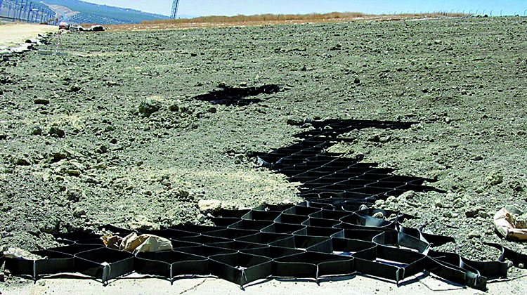
WATERPROOFING AND REVEGETATION OF EXCAVATED EMBANKMENTS WITH GEOTEXTILE AND GEOCELLS
Coordination: Javier Cáceres Martín, biologist
Location: Córdoba-Málaga high-speed line; Puente Genil and Herrera
Subject area: stability and revegetation on embankments for line infrastructure
Date: 2006
CHALLENGE: in one of the hillside clearings for the Cordoba-Malaga high-speed line, near the towns of Puente Genil and Herrera, the clayey slopes were in danger of collapsing. It was essential to avoid the gradual deterioration of the slope, which could generate risks for the railroad traffic and high costs during the maintenance.
“In addition to the stabilization of the entire slope, a three-layer coating was installed every 200 metres: a waterproofing bentonite sheet, and over that, two geotextile support elements to secure a middle layer of sodium bentonite”.
Javier Cáceres, coordinator
SOLUTION: in addition to stabilizing the entire slope, a three-layer coating was installed every 200 metres: a waterproofing bentonite sheet, and over that, two geotextile support elements to secure a middle layer of sodium bentonite. A polyester voided geocomposite structure 10 cm thick was then laid over that, with the hexagonal cells filled with topsoil. This made it possible to carry out the planned hydroseeding treatment to ensure the germination and maintenance of the vegetation.