

Ineco has been using drones for years and has been working on the development of advanced applications, such as the calibration of radio aids or the remote inspection of railway lines and structures. It also participates in European R&D&I projects such as TERRA (ground technologies), IMPETUS (information services) and DOMUS (flight demonstrations), and is currently involved in AMU-LED, which will study the safe use of drones in urban environments until 2023. The company is also part of the EUROCAE WG-115, which, together with its North American equivalent RTCA SC-238, focuses on defining technical requirements for drone detection and neutralisation systems.
DRONE-BASED RADIO NAVIGATION AID CALIBRATION SYSTEM Living up to expectations
Ineco, in an internal innovation project, has developed and successfully tested a system for calibrating radio navigation aids with drones that is cheaper, more manoeuvrable and more accessible than current systems, while maintaining accurate results. After three test campaigns and more than 60 flight hours, the system has demonstrated that it lives up to expectations.
Víctor M. Gordo, aeronautical engineer
Iván Beneyto, telecommunications engineer
Radio navigation aids (VOR, ILS, DME) are ground-based equipment that communicate with airborne aircraft via radio signals, thereby ensuring the safety of air navigation by providing the necessary positioning and guidance signals to keep aircraft adequately separated from the terrain and obstacles. In order to ensure that the functioning of the equipment remains optimal, certain parameters relating to the quality of the signal they emit, such as power, modulations, response delays, etc., must be regularly calibrated. This is currently done using aircraft crewed by specialist pilots and personnel.
There are several limitations to the use of manned flight that do not apply to the use of drones, or RPAS (Remotely Piloted Aircraft Systems). On the one hand, their costs are high and their availability is limited due to the fact that few aircraft of this type exist. This means that they can be heavily used and that equipment can only be checked from time to time, typically with one calibration per year and radio navigation aid. On the other hand, they have reduced manoeuvrability in the air and their presence has an impact on air traffic, making it difficult to carry out certain checks.
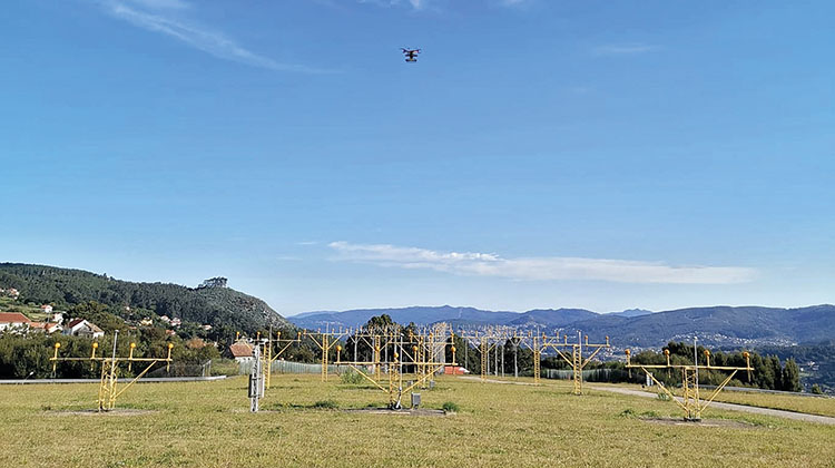
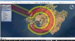
TEST CAMPAIGNS. In order to test the efficiency of the system, several test campaigns have been carried out at Logroño-Agoncillo and Vigo airports, as well as at several air navigation facilities around Madrid. / PHOTO_INECO
Although it is not possible to fully replace manned flight today, since RPAS autonomy is limited and there is no integration with conventional aviation. This technology is poised to become operational as a maintenance support service to enable spot checks and increased spacing between calibration flights.
Over the last few years, Ineco has created its own system for calibrating radio navigation aids using these unmanned vehicles. The system consists of various on-board equipment (so that the drone can analyse the radio signal from the radio navigation aid and send the data back) and equipment on the ground (receiving station), in addition to the analysis and representation software that has been developed.
The platform used is a coaxial octocopter fitted with a Pixhawk 2.1 Cube autopilot system, offering a range of 30 minutes and capacity to carry a payload of up to 2 kg, equipped with GPS+Galileo+GLONASS and EGNOS Navigation system, as well as RTK (Real Time Kinematic) positioning. The on-board systems include antennas, an SDR, or software-defined radio, as well as a microcomputer that analyses the digitised RF signal to calculate the relevant radio navigation aid parameters. The ground system consists of two elements: an RTK base that corrects the drone’s position within a margin of error of centimetres, and a control station that manages all the system’s components.
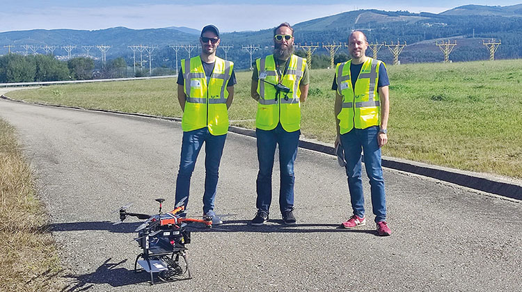
In the image: Iván Beneyto, Ignacio Díaz de Liaño and Víctor Gordo. / PHOTO_INECO
Data is sent in real time via an MQTT (Message Queue Telemetry Transport) broker installed on Ineco’s servers. This broker broadcasts messages to clients via a publisher/subscriber arrangement with latencies of less than two seconds. The visualisation of this data, as well as its storage, is handled by a results console developed in NavTools, Ineco’s air navigation tools package. This console makes it possible to view the records obtained by the equipment on board the drone in real time, displaying how the parameters that define the correct operation of the radio navigation aid, such as the difference in depth of the modulations, power, alignment error, signal structure, etc., evolve along the flight path. The console can also be used to save the received data and to display and analyse the flown trajectory and the data obtained.
In order to assess the efficiency of the system, several test campaigns have been carried out at Logroño-Agoncillo and Vigo airports, as well as at several navigation facilities around Madrid (Perales de Tajuña, Navas del Rey, Castejón and Villatobas), where different types of aids, ILS (Instrument Landing System) and DVOR (Doppler Very-High-Frequency Omnidirectional Range) were tested by means of radial, vertical and horizontal flights, orbits and approaches depending on the type of radio navigation aid.
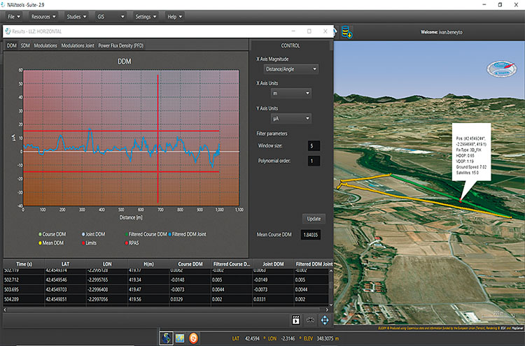
Display of results together with the position of the RPAS (in 3D) in real time, in the tool developed by Ineco. / IMAGE_INECO
The system has made it possible to record the typical parameters of these radio navigation aids, confirming that they were within the ranges established by ICAO for more than 95% of the time, thus complying with current regulations. The results obtained were also compared with those recorded by a conventional calibration aircraft, showing a high correlation, thus corroborating the correct operation of the system; laboratory tests were also carried out using a signal generator, confirming that the system can measure with an error of less than 1%. The most important milestones during these tests are listed below:
- 3 test campaigns in an airport environment.
- 0 ATC incidents.
- More than 10 DVOR verifications.
- More than 10 ILS verifications (LLZ and GP).
- More than 60 cumulative flight hours.
- >95% of the time within ICAO limits.
- Verifications of up to 20 minutes.
- Approaches up to 2 km in length.
- Flights up to 120 metres high.
- Positioning error <1 metre.
- Real-time latencies <2 seconds.
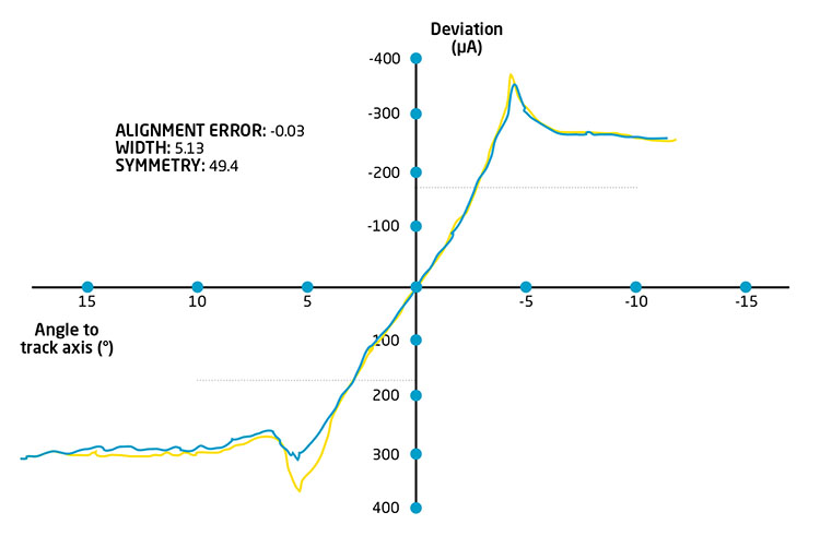
RESULTS VALIDATION. Comparison of drone radio navigation aid calibration results (blue) revealed a high correlation with those of a conventional aircraft (yellow), which corroborates the correct functioning of the system. / SOURCE_INECO
C-UAS: a reality check on rogue drones
Julia Sánchez, UAS specialist, EUROCONTROL
The unmanned aircraft system (UAS/drones) market is rapidly and significantly expanding. What started as an exclusively military domain is now aiming at the private and public civil sectors with numerous applications, that will create new jobs and economic benefits. However, the use of drones raises a number of issues: they can also be dangerous weapons and have become an attractive tool for terrorists and criminals.
A growing phenomenon, is the number of incidents at and around airport facilities. Some actions have already taken place due to the potentially damaging effects of drones’ colliding with other airspace, disrupting aerodrome operations (e.g. such as the incidents at Barajas in February 2020 or Gatwick in December 2018), attacking critical and sensitive infrastructure (e.g. government buildings, nuclear power plants, urban areas) or even people on the ground.
As a consequence of this, the use of UAS has become a double-edged sword. The potential threat that drones pose to safety, security and privacy has led to the development of Counter UAS (C-UAS) measures to counteract any drone incursion into controlled and uncontrolled airspace.
In Europe, the European Commission is committed to supporting EU member states in mitigating the threats posed by non-collaborative UAS, in line with the EU Action Plan to Support the Protection of Public Spaces, the European Commission’s counter-terrorism unit has created two interest groups: Protection of Public Spaces (PPS) and C-UAS,.
EASA’s (European Aviation Safety Agency) Counter-UAS Action Plan was included in the European Plan for Aviation Safety (EPAS) in 2021. It concerns educating drone operators and pilots, raising awareness to prevent the misuse of drones around aerodromes, preparing aerodromes against drones’ incursions, advising aerodromes to consider those C-UAS measures necessary for ensuring the safety and security of aerodrome operations (airborne and ground), encouraging adequate incident reporting, and supporting the assessment of the safety risk drones pose to manned aircraft. The deliverable of the second objective of the Action Plan is a guidance manual called Drone Incident Management at Aerodromes, although only the first part is publicly available.
The European Commission is committed to supporting EU member states in mitigating the threats posed by non-collaborative UAS. EUROCAE has established the Work Group WG 115 in order to develop standards for the safe and harmonised implementation of anti-UAS systems at airports and ANSPs
Faced with these actions, there is also the necessity to choose the right C-UAS technology depending on the threat scenario. EUROCAE, the European Organisation for Civil Aviation Equipment, has established the Work Group WG 115 in order to develop standards for the safe and harmonised implementation of anti-UAS systems at airports and ANSPs. These standards will describe the performance of the system (e.g. minimum level of detection required), interoperability and interfaces with stakeholders. EUROCAE WG 115 jointly with RTCA SC-238 Counter UAS published its first deliverable, the Operational Services and Environment Definition (OSED) for C-UAS in controlled airspace. The scope of this is to introduce the overall capability of a C-UAS system, including capabilities for the detection of unauthorised UAS. EUROCONTROL is highly involved in WG 115 and will continue to support it and contribute to future deliverables, that are expected to be published by the end of 2022.
As EUROCONTROL’s activities touch on operations, concept development, research, safety and security, and performance improvements, we are providing key services and contributing experts in the domain to C-UAS-related research projects from European Commission’s Directorates-General for Migration and Home Affairs and Transport (DG Home and DG Move); the European Aviation Safety Agency (EASA), the European Organisation for Civil Aviation Equipment (EUROCAE), Work Group 115, as well as the international air transport (IATA) and airport associations (ACI).
Furthermore, there are also some limitations to C-UAS technologies in the aviation context, since might interfere with other systems currently in place. Interoperability must therefore be ensured with other systems (e.g. navigational aids, and primary and secondary radars at airports), as well as an interface with appropriate ATM and UTM (U-space) systems to enable the exchange of information necessary for the safe operations. Finally, any technical C-UAS solution must be complemented by procedural measures and clear protocols that depend on the threat level presented by the rogue UAS, to define who does what and when. The C-UAS should also be able to distinguish between authorised and unauthorised drones. A variety of technical C-UAS solutions and technologies are continually emerging. The selection of the right C-UAS depends on the features and specific characteristics of the environment. Actions in response to an illegal UAS, such as mitigation and neutralisation technologies, can carry important risks, and their deployment will fully depend on the national legislation of the country concerned. At the international level, the International Court of Justice (ICJ) mentions that countermeasures must never involve the use of force. Initiatives to improve C-UAS response capabilities could include the development of an official registry or database that allows the rapid classification of a drone as a threat, and the development of a catalogue of best practices when employing C-UAS to know which technology would be more suitable and how to use it, with a clear description of the chain of command to be followed and any legal advice that could be required depending on the type of threat.
Counter-drone systems to protect public safety
Enrique Belda, Deputy Director General of Information and Communications Systems for Security and Director of CETSE
José Cebrián, Chief Inspector of the R&D&I Area and Director of the SIRDEE Office
Manuel Izquierdo, Director of the SIGLO-CD Project
The technological growth in drones, the large number of commercial models and their multiple applications, together with the reduction of purchase and maintenance costs and the ease of operation and legislative development, mean that more and more public and private organisations, individuals and companies are using this type of aircraft. For this reason, the authorities must be prepared in two respects: as users, including the emergency services, and as guarantors of security, both by preventing their reckless use or non-compliance with the rules of manufacture, sale and use (safety), and by preventing their criminal use, in the most serious case, for terrorist attacks (security).
The Ministry of the Interior, and more specifically the Secretary of State for Security, has been working from two perspectives: the legal perspective, including collaborations, action protocols and agreements with other bodies, and the technological perspective, seeking and applying the best existing solutions both for fleet control and to prevent and, where appropriate, neutralise their malicious use.
The Security Technology Centre (CETSE) is the headquarters from the Subdirectorate General of Information and Communication Systems for Security (SGSICS). The R&D&I Area of the Subdirectorate is made up of two departments: R&D&I, European Projects and CoU (Community of Users), and Drones and Counter-Drones, SIGLO-CD Directorate (Global Counter-Drones System).

Enrique Belda, Deputy Director General of Information and Communications Systems for Security and Director of the CETSE, describes the centre as a “factory of technological solutions”, among them, the Global Counter-Drones System (SIGLO-CD). / PHOTO_MINISTRY OF THE INTERIOR
In 2016, a working group was set up at the Secretary of State for Security focused on finding solutions to the malicious use of this type of aircraft. Following an analysis of the market, it was concluded that there are no global solutions to address all situations –most of them are isolated–, that there are many different scenarios with very different characteristics, that there is a lack of legislative regulation in counter-regulatory systems and that these systems may cause possible collateral damage. From the outset, the following phases were established to deal with a potential threat:
- Detection: something strange is detected, but initially it is not clear whether it is a drone, where it is going, what its intentions are, etc.
- Identification: discern whether it is indeed a drone and obtain as much data as possible from the drone, including the pilot’s position.
- Tracking: give indications of where it is going and possible intentions.
- Neutralisation: if necessary.
- Intelligence: all these phases must have a certain amount of intelligence to help the operator make decisions in real time.
In 2019, the Secretary of State for Security (SES) ordered the design and implementation of a technological platform to protect against allegedly unlawful acts (reckless flights or flights with illegal intent), as well as intrusions into personal space, use by organised crime and, in the most serious cases, possible terrorist actions. The Subdirectorate General of Information and Communication Systems for Security (SGSICS) was in charge of implementing the so-called Global Counter-Drones System (SIGLO-CD).
In 2019, the Secretary of State for Security (SES) ordered the design and implementation of a technological platform to protect against alleged unlawful acts, as well as intrusions into personal space, use by organised crime and possible terrorist actions
On 11 July 2019, the Secretary of State for Security signed the emergency resolution declaring the procurement of a global system service. Phase 0 began with the aim of detecting, identifying and tracking commercial drones in the metropolitan area of Madrid and, if necessary, neutralising possible threats to State institutions located in the capital, such as the Royal Palace of Madrid, the Government Presidency, the Congress and the Senate, among others. From the outset, the system has been designed holistically, continuously evolving to adapt to constant technological innovations and to improve the detection, identification, tracking and neutralisation of the majority of drones, regardless of the technology they use.
The client-server architecture is built around a central server (Headquarters) which transmits information to the different detectors via a virtual private network (VPN), through which the neutralisation equipment can be activated, if necessary. SIGLO-CD also has different sites or control centres from where suspected unauthorised drone flights are monitored, each of which has an assigned administrator. In the control rooms, users (advanced or end-users) can manage the information obtained by the detection systems covering the assigned surveillance areas, in accordance with the competences associated with their respective profiles.
ILLUSTRATION_DRON SILENT FLYER, COURTESY: HTTP://FLYGILDI.COM
Both detectors and neutralisers are considered as peripheral devices of the central server housed in the Security Technology Centre (CETSE), in order to provide its different users with drone detection, identification, tracking and neutralisation data in real time. It also stores information and manages communications.
The detection systems that were initially selected are passive, since they are deployed in an urban environment. They obtain the brand, model, serial number or tracking data of the most widespread commercial drones on the market. Its coverage radius is more than 15 km per antenna, which means that a few sensors can cover large areas.
Activity in the sector is constantly growing: in 2020, more than 7,500 drone flights were detected over the urban area of Madrid, of which almost 95% were of the brand DJI. By 2021, the figure had increased to more than 12,000 flights
Over the next three years (2022-2024), the global system is scheduled to be extended to most of the national territory, in order to manage different emergencies in a coordinated manner. It will also ensure compliance with U-Space standards. It is also collaborating with other institutions, such as the Spanish Professional Football League, with whom an agreement has been signed for the installation of detection and neutralisation systems in sports stadiums.
Activity in the sector is constantly growing: in 2020, more than 7,500 drone flights were detected over the urban area of Madrid, of which almost 95% were of the brand DJI. By 2021, the figure had increased to more than 12,000 flights.