
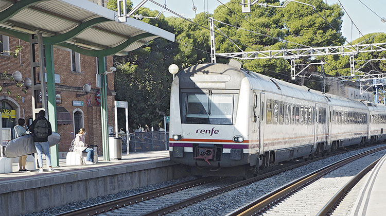
On 24 March 2021, Adif unveiled the new Geographic Information System (GIS) of the Mediterranean Corridor to celebrate the European Year of Railway. The need to develop a GIS arose in response to requests received by the Commissioner’s Office from institutional, economic and social actors: an official, accessible and user friendly, but at the same time technically and graphically detailed means of consultation.
There are interesting and pioneering examples of GIS applications to trans-European corridors, such as the European Commission’s TENtec interactive map of the 9 trans-European corridors or the CIS (Corridor Information System) of the Rhine-Alpine Corridor. However, neither case manages to combine the precision and quantity of information, the speed of consultation and the ease of use that today’s information society demands. For this reason, Adif has emphasised that the Mediterranean Corridor GIS should set four fundamental objectives: providing up-to-date information on its development; displaying its complexity, identifying all the connection nodes; showing its cross-border and European scope; and visualising the work of the Office and the monitoring of the works. The materialisation of these objectives in the form of this interactive portal has attracted attention in the EU, where the tool has been received with interest. Its excellent reception, which exceeded 10,000 visits in the first month, has prompted Adif to plan the development of a GIS for the Atlantic Corridor as well.
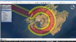
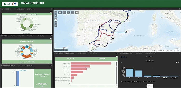
Future scheme of Mediterranean Corridor (Map Viewer).
In order to achieve the aforementioned objectives, a specific working methodology has been developed and articulated in several phases under the direction of the Office of the Mediterranean Corridor. Firstly, it has been necessary to design ad hoc databases to catalogue and process the information related to the Mediterranean Corridor: the technical, socio-economic and geographical aspects of the railway infrastructure, urban nodes, ports and terminals, among others, have been structured and codified in an integrated and coherent manner. This has been very important in order to achieve a geospatial architecture that is both flexible, i.e. allowing periodic reviews, and at the same time rigid, in the sense that no structural modifications are needed and that it is well adapted to other European corridors or other transport networks.
Secondly, all the necessary data and cartographic bases have been collected. This step has relied upon the collaboration of many institutions and companies. Adif’s role in providing geospatial information and very specific data on the railway infrastructure and freight operations, and Ineco’s role in numerous works, studies and projects of the Mediterranean Corridor, both stand out. SNCF Réseau and the Occitania Region were involved in the profiling of the cross-border sector and the French sections. Much data has also been collected from the websites of port authorities, intermodal terminals and private companies websites.
The viewer has a base map to consult all the planned sections under construction and in service and a statistical map with dynamic graphs that summarise the most relevant technical and socio-economic aspects
Thirdly, mapping has been carried out to provide the databases with spatial information. The real challenge has been to harmonise the sectioning of the railway network and the nodes in order to make the sections implemented in the Geographic Information Systems of Adif (IdeADIF) and the European Commission (TENtec) compatible and at the same time coherent with the planning of the works and ongoing studies.
As a result, the network is made up of almost 700 sections between the Network of General Interest and the accesses to terminals and ports, represented in four situations: sections currently in service; in execution; in the study and construction project phase; and, finally, future sections, i.e., when all the actions in progress have been completed.
Nodes, on the other hand, total more than 270 elements. Overall, more than 1,000 elements have been processed, each with its associated geometries and information, with a total of 45,000 attributes. The amount of information to be processed is considerable and continuous revisions (last phase) have been necessary in order to achieve a very high level of accuracy and detail.
In order to show how the Corridor fits in at local and regional level, the layers of the metropolitan and suburban lines of the main urban centres have been incorporated, as well as the major transport networks at ‘Euro-Mediterranean’ level: the route of the European Mediterranean Corridor (to the north), the Trans-Maghreb Corridor (to the south), the maritime connection between Palma de Mallorca and Barcelona/Valencia (to the east) and lastly, Adif’s railway network (to the west).
Finally, a set of socio-economic and environmental indicators have been incorporated in order to understand the Mediterranean Corridor as an axis of territorial structuring, a lever for a more sustainable, resilient and better connected territory. This data will be updated on a regular basis, in line with the progress of the works and ongoing studies. After the data had been validated by Adif, a map viewer was developed in Esri environment that is highly innovative in terms of its structure, content and visualisation. It is available in two different modes: a base map that allows users to consult the information mentioned above, and a statistical map with dynamic graphics that summarise the most relevant technical and socio-economic aspects.
The viewer is hosted on the Hub-GIS of the Office of the Spanish Government Commissioner for the Mediterranean Corridor, where it is possible to consult additional documentation on the Office (reports, annual reports, photos of works in progress, infographics, etc.) and links to related websites. The Hub-GIS is accessible to the public from Adif’s main website and the following link. A searchable user guide has been produced to make it easier to consult and use the viewer.
Using a practical example, it is possible to consult the current status of the mixed-use line between the French border and Barcelona, the type of electrification (25kv), the maximum axle load permitted (22.5t), the gradients in the north and south directions, the total length of the section, etc. We could also visualise the works in progress on the Castellbisbal-Martorell section (mixed gauge installation), known as the ‘Gateway to Europe’ due to its strategic importance for the entire Mediterranean Corridor. The viewer also allows us to visualise the accesses now under construction to the SEAT-Martorell factory, or the remodelling of the Ford factory in Valencia, the new access branches to the ports of Castellón and Sagunto, as well as the dozens of freight terminals and intermodal centres.
The future situation shows what the Mediterranean Corridor will look like once completed and fully interoperable
After reviewing the number of trains handled at a specific terminal (e.g. San Roque freight, on the Algeciras-Bobadilla section), a web link redirects to the functional diagram in Adif’s catalogue of logistics facilities. If, on the other hand, we are interested in knowing where the planned route for the new Murcia-Almería line runs, the corresponding layer would be activated, informing us that the Los Arejos-Vera section has a finished platform, while works are already underway on the adjacent sections. The satellite base map shows the exact location of the project. Finally, the future situation shows how the corridor will look once it is finished, fully interoperable and with passenger stations, freight terminals and urban nodes connected in an intermodal system. In order to understand the Corridor in terms of a territorial project, it is possible to activate some of the economic indicators included in the viewer, such as population per municipality, income per capita at municipal level, tonnes of goods unloaded per province or the level of PM10 and Nitrogen Dioxide (NO2) pollution.
Ineco has been implementing Geographic Information Systems (GIS) for years to respond to the needs of ever more demanding clients in the field of virtual technologies, BIM, Big Data, etc. However, due to its complexity and novelty, this project marks a milestone for the company and for the Office of the Spanish Government Commissioner for the Mediterranean Corridor, which is coordinated by Prof. Josep Vicent Boira.
The collaboration between Ineco and Adif personnel working at the Office is also noteworthy in terms of compiling and reviewing a large volume of data, as well as providing the advice and technical knowledge of their respective railway experts. Meanwhile, UTE TAG-Esteyco has been responsible for the first phase of the processing of technical and cartographic information.
The cartographic portal
Purpose of the Viewer
- To provide economic agents and citizens with information on the development of the Corridor, i.e. to show its current situation, the state of works and projects in progress, and finally the future situation (foreseen according to the current planning of the Ministry of Transport, Mobility and Urban Agenda, MITMA).
- To display its depth and complexity, identifying and characterising the main nodes connected and to be connected to the Corridor: cities, freight terminals, factories, passenger stations, ports and airports.
- To highlight its European nature. To understand the potential of the Corridor, it is necessary to look beyond state borders because the Mediterranean Corridor is a European project that connects six Member States (Spain, France, Italy, Slovenia, Croatia and Hungary, up to the border with Ukraine) and has a clear cross-border nature.
- To streamline the monitoring of works and improve the visualisation of the work of the Office of the Spanish Government Commissioner for the Mediterranean Corridor.
simple and intuitive navigation
- The technical characteristics of the current and future Corridor. Through specific layers on the status of works and ongoing studies. It also includes the future situation, a vision of the Corridor once the planned projects have been completed, meeting the requirements of railway interoperability and intermodality for freight and passenger transport, as well as Regulation 1315/2013.
- Railway accesses and the internal railway network of Adif’s main terminals, ports, logistics centres and factories, specifying current technical characteristics, possible works and studies in progress, and their future situation.
- Freight terminals and passenger stations listed in Regulation 1315/2013, as well as those relevant in the state and regional context.
- The zoning of port terminals.
- The main urban nodes, as well as the medium-sized cities that the Mediterranean Corridor crosses.
- Regional and local transport networks (Commuter hubs and metropolitan lines).
- The characterisation of the railway infrastructure, nodes and terminals in the south of France (Occitania region), in line with the cross-border vision of the Office of the Commissioner.
- Other transport networks that give continuity and complement the Corridor in a ‘Euro-Mediterranean’ sense, i.e. the Palma de Mallorca maritime connection with Barcelona and Valencia, the Trans-European Mediterranean Corridor (up to the Hungarian-Ukrainian border), the Adif railway network and the Trans-Maghreb Corridor.
- Socio-economic and environmental indicators to understand the Corridor as a territorial structuring project that brings benefits in terms of local, regional and national socio-economic growth in a sustainable and resilient manner.
Josep Vicent Boira (Government Commissioner)

THE MEDITERRANEAN CORRIDOR IN 2021
By Josep Vicent Boira, Government Commissioner for the Mediterranean Corridor
Anniversaries are a good time to understand where we have come from and where we are going. This year, 2021, we have three reasons to celebrate in the Mediterranean Corridor. The first is that this year has been declared the ‘European Year of Railway’ and because our work is aimed at a mode of transport that is set to play a strategic role in the coming decades, we feel a part of this celebration. The European Union is turning its attention to trains, both passenger and freight. The United States is also doing the same, with a president, Joseph R. Biden, who has not only given his name to a station (Wilmington station, for the reason that as a senator for Delaware, he used it every day to commute to Washington), but is already beginning to be known as ‘Amtrack Joe’ because of his enthusiasm for railway travel. In Europe, this year could be an excellent opportunity to talk about full European interoperability, to abolish the costs of different gauges, to finally achieve full freedom of movement within a single European railway system.
Two further anniversaries are of interest to us in 2021. First of all, it’s our 10th anniversary. The Mediterranean Corridor was declared part of the Trans-European Transport Network (TEN-T) in October 2011, when Commissioner Siim Kallas reformulated the plans for priority European infrastructure projects to include lines, such as ours, which had mysteriously been left out of previous plans. This marks the beginning of a real network that is due to be completed by 2030 and which will play an important role in the urgent European challenge of achieving climate neutrality through the decarbonisation of transport. If other EU partners should be running towards this goal, in Spain (due to the disproportionate share still held by road freight transport) we should be flying, not like aeroplanes, but like the high-speed trains that are the future of internal and external transport. This is not a question of attacking road transport, but of moving towards rail, as society as a whole is already doing.
Finally, in 2021, it is also worth looking back at where we have come from. This year we are celebrating 160 years since the Valencia-Tarragona route was approved by Royal Order on 21 March 1861. This section was the link that made it possible to connect the railway developments that were already taking place in the north and south of the Mediterranean axis. On one side, the Sociedad de Ferrocarriles de Almansa a Valencia y Tarragona (AVT), created with the support of the Sociedad Valenciana de Fomento, worked in the Valencian area, while the Catalana General de Crédito worked in Catalonia. In 1861, authorisation was given to link the two local networks in order to continue the project towards France. The progress of the line was remarkable: on 20 April 1862 the Valencia-Sagunto section was inaugurated, by 21 August the train had reached Nules and on 26 December it reached Castellón. On 21 June 1868, shortly after the inauguration of the bridge over the River Ebro, the first train travelled the new route with great expectations among agricultural exporters as it allowed access to France thanks to the Catalan network, which was completed in 1878, when, after the necessary changeover due to the different gauge, the border link of Portbou with the French company of the Midi was established.
1861, 2011 and 2021 are milestones in a process that must go on. New technologies have meant that this year we now have access to an open and freely accessible Geographic Information System for the Mediterranean Corridor, which will soon be followed by another for the Atlantic Corridor. The European coordinator of the Mediterranean Corridor of the TEN-T Network has congratulated us and expressed the hope that one day the entire route of the Corridor, from Algeciras to Záhony, in Hungary, will be equipped with a tool like this. However, technological progress and the effort to make public works transparent is useless if we do not know where we have come from and where we want to go. We are heirs to those old steam and coal trains that first roared across the land more than 150 years ago for a more prosperous society and we as citizens of the European Union are part of the generation that is laying the foundations for cleaner, more sustainable and safer transport and trade. 2021 will, therefore, be a year to remember.